
 Continue with onX Maps
 Sign in with Facebook


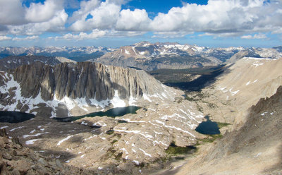
 Particularly Special Place


Noteworthy Backpacking Routes
near Woodlake, California
Woodlake, California 
Recommended Routes, Photos, & More

 Difficult
Mount Whitney via Mount Whitney Trail
20.5 mi 33.0 km • 6,404' Up 1951.98 m Up • 6,405' Down 1952.1 m Down
 Lone Pine, CA
 Difficult
Rae Lakes Loop
40.4 mi 65.0 km • 7,007' Up 2135.69 m Up • 7,007' Down 2135.68 m Down
Squaw V…, CA
 Difficult
High Sierra Trail
66.5 mi 107.0 km • 15,521' Up 4730.66 m Up • 13,863' Down 4225.31 m Down
Three R…, CA
 Difficult
North Lake to South Lake
55.3 mi 89.1 km • 9,655' Up 2942.92 m Up • 9,199' Down 2803.88 m Down
West Bi…, CA
 Difficult
John Muir Trail (JMT)
213.2 mi 343.2 km • 45,167' Up 13766.9 m Up • 34,723' Down 10583.7 m Down
Yosemit…, CA
Difficult
Cottonwood Pass Trail to Whitney Portal
38.7 mi 62.3 km • 7,417' Up 2260.62 m Up • 8,973' Down 2734.97 m Down
Lone Pine, CA
 Difficult
Eastern Sierra Tour
66.9 mi 107.6 km • 8,476' Up 2583.59 m Up • 8,477' Down 2583.64 m Down
Lone Pine, CA
 Difficult
Copper Creek Trail
15.7 mi 25.2 km • 5,121' Up 1560.98 m Up • 5,120' Down 1560.58 m Down
Squaw V…, CA

 Intermediate
Kearsarge Pass Out and Back
9.6 mi 15.4 km • 2,571' Up 783.79 m Up • 2,570' Down 783.26 m Down
 Lone Pine, CA

 Intermediate/Difficult
Jennie Lake Out and Back
13.9 mi 22.4 km • 2,428' Up 739.95 m Up • 2,427' Down 739.66 m Down
Three R…, CA
 Intermediate
Big Pine Lakes
13.1 mi 21.2 km • 3,182' Up 969.82 m Up • 3,171' Down 966.46 m Down
Big Pine, CA

 Very Difficult
Shepherd Pass Out-And-Back
21.6 mi 34.8 km • 6,838' Up 2084.24 m Up • 6,835' Down 2083.4 m Down
Lone Pine, CA
 Intermediate/Difficult
Bishop Pass Trail to Dusy Basin
17.5 mi 28.2 km • 4,404' Up 1342.28 m Up • 4,401' Down 1341.54 m Down
Big Pine, CA
 Intermediate/Difficult
East Lake from Roads End
25.5 mi 41.1 km • 4,580' Up 1395.98 m Up • 4,580' Down 1395.88 m Down
Squaw V…, CA
 Difficult
Cirque Lake via South Fork Cottonwood Creek
10.1 mi 16.3 km • 1,341' Up 408.8 m Up • 1,341' Down 408.73 m Down
Lone Pine, CA
 Intermediate/Difficult
Kearsarge Lakes and Bullfrog Lake
14.6 mi 23.6 km • 3,847' Up 1172.64 m Up • 3,846' Down 1172.16 m Down
Lone Pine, CA
Difficult
Cirque Lake Loop
23.0 mi 37.0 km • 3,756' Up 1144.8 m Up • 3,755' Down 1144.59 m Down
Lone Pine, CA
 Difficult
Hamilton Lakes Basin
31.1 mi 50.0 km • 7,108' Up 2166.61 m Up • 7,107' Down 2166.27 m Down
Three R…, CA
 Difficult
Mount Langley via New Army Pass
23.9 mi 38.5 km • 5,108' Up 1556.77 m Up • 5,108' Down 1556.8 m Down
Lone Pine, CA
 Intermediate/Difficult
Chocolate Lakes Loop
6.8 mi 11.0 km • 1,601' Up 488.03 m Up • 1,602' Down 488.3 m Down
Big Pine, CA
 Very Difficult
Beveridge Ghost Town
18.4 mi 29.6 km • 8,999' Up 2742.84 m Up • 8,999' Down 2742.79 m Down
 Difficult
Mono Pass Trail to Summit Lake
4.1 mi 6.5 km • 1,773' Up 540.49 m Up • 142' Down 43.37 m Down
 Intermediate/Difficult
Golden Trout Creek Loop
25.0 mi 40.3 km • 3,095' Up 943.37 m Up • 3,094' Down 943.2 m Down
 Difficult
Lillian Lake Loop
12.5 mi 20.2 km • 2,045' Up 623.21 m Up • 2,056' Down 626.54 m Down
 Difficult
Rutherford and Anne Lakes
1.1 mi 1.8 km • 257' Up 78.21 m Up • 274' Down 83.61 m Down
 Difficult
Sixty Lakes Basin Out and Back
30.4 mi 49.0 km • 7,981' Up 2432.52 m Up • 7,980' Down 2432.33 m Down
 Difficult
Tehipite Valley
31.3 mi 50.3 km • 6,375' Up 1943.02 m Up • 6,376' Down 1943.36 m Down
 Difficult
Heart of the Domelands
28.3 mi 45.6 km • 3,737' Up 1139.09 m Up • 3,763' Down 1146.98 m Down


