
 Continue with onX Maps
 Sign in with Facebook


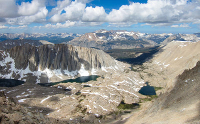
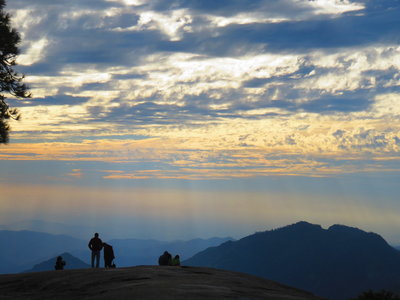
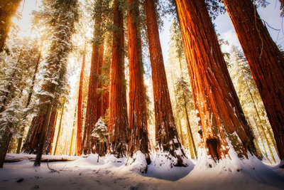
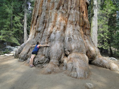
 Particularly Special Place


Top Recommended Hiking Routes
near Woodlake, California
Woodlake, California 
Recommended Routes, Photos, & More

 Difficult
Mount Whitney via Mount Whitney Trail
20.5 mi 33.0 km • 6,404' Up 1951.98 m Up • 6,405' Down 1952.1 m Down
 Lone Pine, CA

 Intermediate/Difficult
Lakes Trail
12.8 mi 20.5 km • 2,813' Up 857.36 m Up • 2,812' Down 857.18 m Down
Three R…, CA
 Intermediate/Difficult
Moro Rock Trail
3.9 mi 6.2 km • 369' Up 112.32 m Up • 369' Down 112.37 m Down
 Three R…, CA
 Difficult
Rae Lakes Loop
40.4 mi 65.0 km • 7,007' Up 2135.69 m Up • 7,007' Down 2135.68 m Down
Squaw V…, CA
 Easy/Intermediate
Congress Trail
1.9 mi 3.0 km • 350' Up 106.6 m Up • 314' Down 95.62 m Down
Three R…, CA
 Difficult
Alta Peak from Wolverton
14.1 mi 22.6 km • 3,939' Up 1200.65 m Up • 3,938' Down 1200.31 m Down
Three R…, CA
 Difficult
Deer Lakes Loop
13.3 mi 21.5 km • 2,857' Up 870.75 m Up • 2,878' Down 877.15 m Down
Mammoth…, CA
 Difficult
Mineral King Loop
25.6 mi 41.3 km • 9,101' Up 2773.89 m Up • 9,091' Down 2771.03 m Down
Three R…, CA
Difficult
High Sierra Trail
66.5 mi 107.0 km • 15,521' Up 4730.66 m Up • 13,863' Down 4225.31 m Down
Three R…, CA
 Difficult
North Lake to South Lake
55.3 mi 89.1 km • 9,655' Up 2942.92 m Up • 9,199' Down 2803.88 m Down
West Bi…, CA
 Difficult
Glacier Lodge to Palisade Glacier
17.3 mi 27.8 km • 4,674' Up 1424.58 m Up • 4,674' Down 1424.49 m Down
Big Pine, CA
 Intermediate
Giant Forest Loop Trail
7.5 mi 12.0 km • 972' Up 296.24 m Up • 952' Down 290.23 m Down
Three R…, CA
 Difficult
John Muir Trail (JMT)
213.2 mi 343.2 km • 45,167' Up 13766.9 m Up • 34,723' Down 10583.7 m Down
Yosemit…, CA
 Intermediate
Mist Falls
8.2 mi 13.1 km • 805' Up 245.38 m Up • 804' Down 245.19 m Down
Squaw V…, CA
 Intermediate
Grand Tour of Sequoias in Mariposa Grove
3.3 mi 5.3 km • 1,092' Up 332.7 m Up • 244' Down 74.42 m Down
Oakhurst, CA
Difficult
Cottonwood Pass Trail to Whitney Portal
38.7 mi 62.3 km • 7,417' Up 2260.62 m Up • 8,973' Down 2734.97 m Down
Lone Pine, CA
 Intermediate/Difficult
Chilnualna Falls Out and Back
7.8 mi 12.6 km • 2,165' Up 659.96 m Up • 2,168' Down 660.92 m Down
Midpines, CA

 Very Difficult
Mt Whitney via the Mountaineer's Route
9.2 mi 14.9 km • 5,928' Up 1806.72 m Up • 5,919' Down 1804.14 m Down
Lone Pine, CA
 Easy/Intermediate
Convict Lake Trail
2.6 mi 4.1 km • 170' Up 51.72 m Up • 175' Down 53.4 m Down
Mammoth…, CA
 Intermediate
Marble Falls Trail
6.8 mi 11.0 km • 1,531' Up 466.59 m Up • 1,531' Down 466.57 m Down
Three R…, CA
 Easy/Intermediate
Zumwalt Meadows Loop Trail
1.3 mi 2.0 km • 104' Up 31.7 m Up • 123' Down 37.52 m Down
Squaw V…, CA
 Intermediate
Redwood Mountain Grove: Hart Trail & Sugar Bowl Trail Loops
9.9 mi 16.0 km • 1,929' Up 587.85 m Up • 1,912' Down 582.87 m Down
Three R…, CA
 Intermediate
Methuselah Loop Trail
4.1 mi 6.5 km • 731' Up 222.78 m Up • 731' Down 222.87 m Down
Dixon L…, CA
 Intermediate/Difficult
Morgan Pass and Gem Lake
8.0 mi 12.9 km • 941' Up 286.85 m Up • 942' Down 286.97 m Down
West Bi…, CA
 Difficult
Ram Lake via Duck Pass and John Muir Trail
20.4 mi 32.8 km • 4,163' Up 1268.86 m Up • 4,165' Down 1269.57 m Down
Mammoth…, CA
 Very Difficult
Bloody Mountain via Laurel Lakes Road and the Northeast Ridge
14.1 mi 22.7 km • 5,100' Up 1554.34 m Up • 5,099' Down 1554.03 m Down
Mammoth…, CA
 Easy
Easy
Giant Forest: Big Trees Trail
1.3 mi 2.1 km • 93' Up 28.27 m Up • 91' Down 27.7 m Down
Three R…, CA
 Difficult
Eastern Sierra Tour
66.9 mi 107.6 km • 8,476' Up 2583.59 m Up • 8,477' Down 2583.64 m Down
Lone Pine, CA


