
 Continue with onX Maps
 Sign in with Facebook


 Particularly Special Place


Top Rated Hiking Trails
near Chilmark, Massachusetts
Chilmark, Massachusetts 
Recommended Routes, Photos, & More

 Easy
Easy
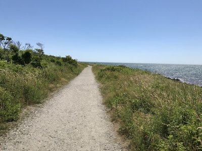
Ocean View Loop Trail
1.5 mi 2.5 km • 40' Up 12.19 m Up • 36' Down 11.12 m Down
 Newport, RI
 Easy
Easy
Needham Reservoir Trail
0.5 mi 0.8 km • 8' Up 2.4 m Up • 7' Down 2.23 m Down
Needham, MA

 Intermediate
Sammy C Trail
3.2 mi 5.2 km • 254' Up 77.47 m Up • 264' Down 80.39 m Down
Charles…, RI
 Easy
Easy
Atlantic White Cedar Trail
1.1 mi 1.8 km • 80' Up 24.36 m Up • 86' Down 26.14 m Down
North E…, MA
 No Photos
Intermediate
No Photos
Intermediate
Morses Pond Trail
1.1 mi 1.8 km • 41' Up 12.41 m Up • 37' Down 11.36 m Down
Wellesley, MA
No Photos
Intermediate
Moraine Trail - Northern Section
2.7 mi 4.3 km • 208' Up 63.25 m Up • 244' Down 74.33 m Down
West Fa…, MA
No Photos
Intermediate
Horseneck Beach Loop
1.7 mi 2.8 km • 29' Up 8.92 m Up • 30' Down 9.1 m Down
Head of…, MA

 Difficult
Yellow Trail
2.0 mi 3.3 km • 8' Up 2.58 m Up • 94' Down 28.56 m Down
Tiverton, RI
 Intermediate
Page & Sadie Trail
1.7 mi 2.8 km • 79' Up 24.12 m Up • 87' Down 26.57 m Down
Westwood, MA
 Intermediate
Red Trail
2.1 mi 3.4 km • 89' Up 27.1 m Up • 69' Down 20.92 m Down
Bliss C…, MA

 Easy/Intermediate
Acton Path
1.8 mi 2.9 km • 44' Up 13.51 m Up • 27' Down 8.12 m Down
Canton, MA
 Easy/Intermediate
Canonchet Trail
2.9 mi 4.7 km • 122' Up 37.25 m Up • 317' Down 96.73 m Down
Hopkinton, RI
No Photos
Intermediate
Ridge Trail
1.2 mi 2.0 km • 148' Up 45.22 m Up • 131' Down 39.86 m Down
Dover, MA
No Photos
Easy
Loop Trail
1.1 mi 1.8 km • 121' Up 36.79 m Up • 119' Down 36.38 m Down
Canton, MA
No Photos
Intermediate
Main Loop (Blue Trail)
0.7 mi 1.2 km • 29' Up 8.83 m Up • 12' Down 3.65 m Down
Stow, MA
No Photos
Easy
Pond Loop
0.4 mi 0.6 km • 20' Up 6.15 m Up • 18' Down 5.53 m Down
Arlington, MA
 Intermediate
Meadow Ridge Trail
1.3 mi 2.2 km • 289' Up 88.01 m Up • 140' Down 42.57 m Down
Paxton, MA
No Photos
Intermediate
Quarry Trail
0.8 mi 1.2 km • 58' Up 17.62 m Up • 90' Down 27.53 m Down
Medfield, MA
No Photos
Intermediate
Healthy Heart Trail
1.3 mi 2.1 km • 66' Up 20.13 m Up • 61' Down 18.72 m Down
Foxborough, MA
No Photos
Intermediate
Yellow Trail
0.4 mi 0.7 km • 28' Up 8.6 m Up • 4' Down 1.19 m Down
Stow, MA

 Intermediate/Difficult
Geology Loop (Red)
1.7 mi 2.8 km • 213' Up 64.91 m Up • 206' Down 62.68 m Down
Lexington, MA
No Photos
Easy
Pond Loop
1.5 mi 2.4 km • 16' Up 4.98 m Up • 14' Down 4.4 m Down
Jamaica…, MA
 Easy/Intermediate
Narragansett Trail: Green Falls Section
2.0 mi 3.3 km • 232' Up 70.67 m Up • 56' Down 17.14 m Down
Preston…, CT
No Photos
Intermediate
Ponkapoag Pond Loop
1.1 mi 1.8 km • 71' Up 21.52 m Up • 64' Down 19.48 m Down
Milton, MA
 Intermediate/Difficult
Jericho Hill White Trail
0.7 mi 1.1 km • 176' Up 53.7 m Up • 153' Down 46.78 m Down
Marlbor…, MA
No Photos
Intermediate
Rock Hill Extension
0.8 mi 1.3 km • 115' Up 34.91 m Up • 128' Down 38.94 m Down
Westwood, MA
No Photos
Intermediate
Yellow Trail
0.8 mi 1.3 km • 43' Up 13.25 m Up • 54' Down 16.34 m Down
Bliss C…, MA
 Intermediate
Cedar Hill Overlook
0.1 mi 0.2 km • 49' Up 14.88 m Up • 15' Down 4.67 m Down
Dover, MA


