Continue with onX Maps
 Sign in with Facebook


 Particularly Special Place


Top Recommended Hiking Routes
near Oka, Quebec Canada
Oka, Quebec Canada 
Recommended Routes, Photos, & More

 Difficult
Sunset Ridge Out-and-Back
5.1 mi 8.2 km • 2,496' Up 760.9 m Up • 2,491' Down 759.16 m Down
 Jericho, VT
Difficult
Jericho, VT
Difficult
Halfway House Trail to Sunset Ridge
6.0 mi 9.6 km • 2,581' Up 786.63 m Up • 2,578' Down 785.84 m Down
Jericho, VT
 Difficult
Stowe Pinnacle Trail
3.3 mi 5.3 km • 1,523' Up 464.09 m Up • 1,522' Down 463.91 m Down
 Stowe, VT

 Intermediate/Difficult
Catamount Mountain Trail
3.7 mi 5.9 km • 1,577' Up 480.74 m Up • 1,577' Down 480.64 m Down
Lake Pl…, NY
 Difficult
Johannsen-Sommets-Grand Brule
11.0 mi 17.7 km • 2,614' Up 796.85 m Up • 2,617' Down 797.65 m Down
Mont-Tr…, QC

 Intermediate
Park Loop
2.2 mi 3.5 km • 219' Up 66.6 m Up • 223' Down 68.08 m Down
Burlington, VT
 Intermediate
Niquette Bay State Park Outer Loop
3.4 mi 5.5 km • 553' Up 168.63 m Up • 553' Down 168.46 m Down
Colchester, VT
 Intermediate
Hoyt Lookout-Eagle Mountain Loop
1.5 mi 2.5 km • 233' Up 71.14 m Up • 231' Down 70.43 m Down
Milton, VT
 Intermediate
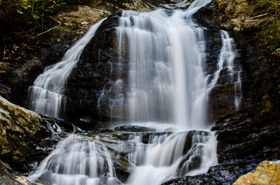
Moss Glen Falls Out and Back
1.4 mi 2.3 km • 298' Up 90.81 m Up • 299' Down 91.01 m Down
Stowe, VT