
 Continue with onX Maps
 Sign in with Facebook


 Particularly Special Place


Newest Recommended Hiking Routes
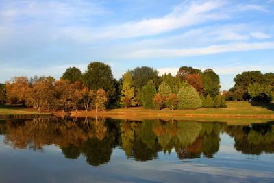
near Lake Murray of Richland, South Carolina
Lake Murray of Richland, South Carolina 
Recommended Routes, Photos, & More


 Easy
Easy
Turkey Oak Trail
1.9 mi 3.0 km • 79' Up 24.19 m Up • 79' Down 24.21 m Down

 Intermediate
Milliken & Company Arboretum Main Trail
3.7 mi 6.0 km • 94' Up 28.62 m Up • 93' Down 28.28 m Down
 Intermediate
Skinner's Shed Out-and-Back
3.1 mi 4.9 km • 171' Up 52.21 m Up • 171' Down 52.14 m Down
 Intermediate
Poinsett Loop Hike
7.9 mi 12.8 km • 469' Up 143 m Up • 478' Down 145.65 m Down

 Easy/Intermediate
Peachtree Figure-Eight Hike
2.7 mi 4.4 km • 191' Up 58.14 m Up • 192' Down 58.38 m Down
 Gaston, SC

 Intermediate/Difficult
Congaree Long Loop
6.9 mi 11.1 km • 244' Up 74.32 m Up • 243' Down 74.17 m Down
 Intermediate
Harbison Long Loop
8.0 mi 12.9 km • 530' Up 161.46 m Up • 538' Down 164.13 m Down
 Easy/Intermediate
Reedy Creek - Big Oak, Umbrella, and Dragonfly Loop
1.9 mi 3.1 km • 135' Up 41.01 m Up • 135' Down 41.03 m Down
Harrisburg, NC
 Easy
Easy
McAlpine Creek Loop
2.6 mi 4.2 km • 26' Up 8.07 m Up • 27' Down 8.2 m Down
Matthews, NC
 Intermediate
Kings Mountain Battlefield Loop
1.6 mi 2.6 km • 203' Up 61.93 m Up • 203' Down 61.84 m Down
 Intermediate
DuPont Waterfall Bonanza
14.1 mi 22.7 km • 1,472' Up 448.73 m Up • 1,503' Down 458.01 m Down
 Intermediate/Difficult
Bracken Preserve Loop
4.6 mi 7.5 km • 767' Up 233.86 m Up • 766' Down 233.62 m Down
Brevard, NC
 Intermediate/Difficult
Crowders Triple Peak
12.9 mi 20.8 km • 2,485' Up 757.41 m Up • 2,479' Down 755.45 m Down
Besseme…, NC
 Intermediate
Mountain Island Park Trail
3.3 mi 5.2 km • 61' Up 18.72 m Up • 62' Down 18.75 m Down
Mount H…, NC

 Very Difficult
Jones Gap - Caesars Head Loop
28.5 mi 45.9 km • 6,337' Up 1931.51 m Up • 6,336' Down 1931.18 m Down
Slater-…, SC
 Easy/Intermediate
Lake Placid Trail
0.9 mi 1.4 km • 126' Up 38.38 m Up • 123' Down 37.62 m Down
Wade Ha…, SC

 Difficult
Pinnacle Trail to Table Rock Loop
10.9 mi 17.6 km • 2,899' Up 883.69 m Up • 2,899' Down 883.75 m Down
Pickens, SC
 Intermediate
DuPont State Forest Triple Falls Loop
3.1 mi 5.0 km • 388' Up 118.35 m Up • 389' Down 118.47 m Down
Brevard, NC
 Intermediate
Glassy Mountain
3.3 mi 5.3 km • 601' Up 183.25 m Up • 601' Down 183.27 m Down
Flat Rock, NC
 Intermediate/Difficult
Coontree Loop
3.5 mi 5.7 km • 1,007' Up 306.94 m Up • 1,007' Down 307.06 m Down
 Easy/Intermediate
South Fork Trail
4.2 mi 6.8 km • 65' Up 19.8 m Up • 65' Down 19.78 m Down
 Difficult
Green River Game Lands Loop #2
8.4 mi 13.6 km • 1,632' Up 497.37 m Up • 1,643' Down 500.83 m Down
East Fl…, NC
 Difficult
Green River Game Lands Loop #1
5.6 mi 9.0 km • 984' Up 299.9 m Up • 990' Down 301.61 m Down
Dana, NC
 Intermediate
King Mountain National Recreation Trail Loop
15.6 mi 25.1 km • 1,148' Up 350 m Up • 1,148' Down 349.9 m Down
 Intermediate
Saluda Mountains Passage
11.9 mi 19.2 km • 1,928' Up 587.69 m Up • 1,929' Down 588.01 m Down
 Intermediate/Difficult
Art Loeb & North Slope Loop
7.4 mi 11.8 km • 1,330' Up 405.5 m Up • 1,329' Down 405.11 m Down
 Difficult
Jones Gap Loop
12.6 mi 20.3 km • 3,318' Up 1011.38 m Up • 3,319' Down 1011.63 m Down
Slater-…, SC
 Intermediate
Wildcat Nature Trail Loop
1.1 mi 1.8 km • 179' Up 54.47 m Up • 186' Down 56.78 m Down


